The Barnes Aquifer Protection Advisory Committee (BAPAC) is a coalition of 4 Massachusetts communities — Easthampton, Holyoke, Southampton and Westfield and the Pioneer Valley Planning Commission. Committee members work together to protect the aquifer, an important regional groundwater resource. BAPAC addresses water quality issues, and educates and advises local governments, citizen groups, and small businesses about groundwater protection and effects on the aquifer. The committee also reviews “Developments of Regional Impact” within the aquifer and provides comments to approval authorities.
About BAPAC

Overview
Why We Were Created
In December 1989, the chief elected officials in the Cities of Westfield and Holyoke, the Towns of Easthampton and Southampton, and the Pioneer Valley Planning Commission signed the “Memorandum of Agreement for Barnes Aquifer Protection” at a public ceremony. This agreement to act cooperatively to protect a natural resource of regional significance was the culmination of a yearlong planning effort by PVPC and a voluntary advisory task force of local officials and residents. The intergovernmental compact created a standing Barnes Aquifer Protection Advisory Committee (BAPAC) with the authority to review and comment on “developments of regional impact” (DRIs) in the aquifer recharge area, and to develop a regional aquifer protection strategy.
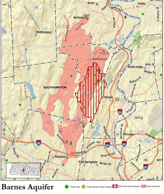
About the Barnes Aquifer
The Barnes Aquifer is held within sand and gravel deposits that were layed down approximately 15,000 years ago by a retreating continental glacier. The aquifer supplies water to 4 municipalities within the Connecticut River Valley, including the cities of Easthampton, Holyoke, and Westfield, as well as the Town of Southampton. Currently 11 active municipal wells and the 108 unit Hendrick Street well field supply 1.2 billion gallons of water per year to 60,000 people in these communities.
Formation of the Aquifer
Overview
The Barnes Aquifer is made up of sediment deposited by streams flowing off the ice of melting glaciers that covered our region numerous times during the last 2 million years (Pleistocene Epoch). The last ice sheet approximately 15,000 years ago was centered at Hudson Bay, Canada, and extended south to Long Island, New York.
Melting of the continental glaciers produced huge quantities of water and sediment. Meltwater streams were effective in sorting the sediment eroded by the ice. The silt and clay size material was transported into lakes or carried all the way to the sea while the sand and gravels were deposited within the channels and floodplains of the meltwater streams or in deltas at the margins of glacial lakes. When the glaciers left the area the meltwater streams dried up and the sorted sands and gravels were left behind.
Lake Hitchcock
As the ice front retreated northward up the Connecticut River Valley, a large glacial lake formed. This lake was dammed by glacial sediment filling the valley near New Britain, Connecticut. At its maximum, this lake, now known as Lake Hitchcock, extended from central Connecticut northward to St. Johnsbury in Vermont. Meltwater streams emerging from the ice at the snout of the glacier deposited sands and gravels into the lake in the form of ice-contact deltas. The size of these deltas was controlled by the size of the meltwater stream and the amount of time the ice front remained at any one place.
Formation of the Aquifer
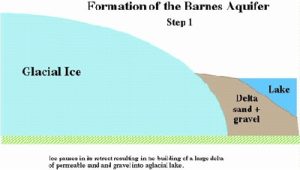
The ice front paused or retreated very slowly as it moved across the Westfield, West Holyoke, Southampton and southern Easthampton area. This allowed the building of a large delta whose sediments form much of the Barnes Aquifer (Stage 1).
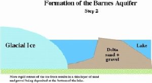
The ice front began to retreat much more rapidly as it moved north of the Plains area of Easthampton. During the more rapid retreat of the ice, meltwater streams emerging from the ice into the lake did not have time to build a delta. Instead, sands and gravels were deposited as a relatively thin apron at the bottom of the lake Aquifer (Stage 2).
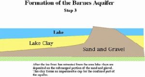
 After the ice front retreated north of Easthampton, these sands and gravels were buried by glacial lake sediments composed of alternating bands of silty sand and clay (varves). These lake sediments extend up the sides but not over the tops of the deltas Aquifer (Stage 3). Eventually the sediments that dammed Lake Hitchcock were eroded and the lake drained exposing the sediments that make up the Barnes Aquifer.
 The Barnes Aquifer is composed of well-sorted, sands and gravels that were deposited by meltwater streams flowing into a glacial lake. The coarse grain-size and excellent sorting of the sediment accounts for its having a high permeability.
Drinking Water
Best Tasting Drinking Water in the Nation
The Barnes Aquifer yields such great drinking water, local communities have twice captured the gold medal for best tasting water in the United States. In 2015, Easthampton took home the gold and Southampton received this same honor in 2008.
Info for Property
The journey of water to our glass involves the feeding of groundwater supplies by nearby rivers and streams and by rain and snowmelt soaking into soils. These groundwater supplies within the Barnes Aquifer are literally beneath our feet. So what you, your family, and neighbors do aboveground can have important consequences for drinking water sources below ground. You can think of your property and surrounding area as a giant sponge that soaks up not only rainfall but much of what may come with it.
Following are some good tips, resources, and links to help us all keep our drinking water safe.
- Your drinking water supply: Protecting it through the seasons
- Taking a chemical free approach to lawn and garden care.
Beyond Pesticides
Organic Lawn Care for Consumers - Reducing the demand on groundwater resources/water conservation: EPA Water Sense
- Promoting aquifer recharge: Keeping stormwater close to where it falls
- Finding alternatives to carcinogenic coal tar sealants:
Findings on Coal-Tar-Based Pavement Sealcoat, USGS (pdf)
Alternatives, Minnesota Pollution Control Agency (pdf) - Take your car’s used oil with your sales receipt to service
stations or auto dealerships that have storage and proper
disposal facilities. Do not drain the oil onto the ground or into storm drains in the street. - If you have a septic system, keep it in good working order and avoid putting toxic or hazardous substances down the drain. For more information, click here.
Info for Developers
Development within the Barnes Aquifer requires special consideration of the extraordinary drinking water source beneath the surface of the land.
Cooperative planning and review of land use and development projects is a major piece of BAPAC’s ongoing work. Planning boards regularly refer proposed projects occurring within the aquifer to BAPAC for review. These projects, known as Developments of Regional Impact (DRIs), can include site plan approvals, special permits, subdivision proposals, zoning amendments, and removal of property from the Chapter 61, 61a, or 61b program. BAPAC’s recommendations on these projects ensure the continued quality and availability of groundwater from the Barnes Aquifer to meet present and future needs.
Below, please see links to resources that may be helpful in thinking about your project. For specific municipal regulations, please see the official websites for Easthampton, Holyoke, Southampton, and Westfield.